
At the special City Council meeting last night, Council unanimously approved staff’s recommendation to move ahead swiftly with Option B (a centered layout) for the shortening and re-striping project to reduce the Santa Monica Airport runway from 5000′ to 3500′. This option was the one overwhelmingly favored in public input on the matter. In addition Council found that the re-striping approach was “categorically exempt” from CEQA and thus could move forward immediately with construction completion anticipated before the end of the year.
Once that was done, Council then (and also unanimously) passed a motion instructing staff to come back to them as soon as possible with options for the removal and repurposing of all the runway surface in excess of the 3500′ required by the new layout. This second phase removal of the surface is a key point that the community has stressed must swiftly follow the re-striping project. Airport2Park sees this directive as the starting gun for Phase-2 ‘Great Park’ planning.
Airport2Park wishes to thank Council and staff for their steadfast (and always unanimous) support in the on-going stepwise process of converting the airport land into the “Great Park” we all anticipate as a result of the passage of Measure LC and the full closure of the airport at the end of 2028.
Shortly after news of the Consent decree became public, Airport2Park members began studying the potential, and advocating for the additional land freed up at either end of the shortened runway to become “Phase-2” of the three phase process Airport2Park laid out in early 2015 to bring about the “Great Park”. “Phase-1” was the initial 12-acre expansion of the existing Airport Park which we first pointed out, and advocated for, starting shortly after the passage of Measure LC (see Fig-1 – original pre-consent decree parcel map below with phase-1 areas circled in red). Thanks to unwavering Council and staff support, Phase-1 is well on its way to becoming a reality (see here for details).
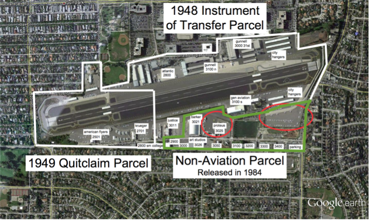
Fig-1 – Airport Parcels Showing initial 12 acres (from Jan 2015 document)
While it will be months before the runway shortening is completed, given Council’s actions last night, Airport2Park’s focus now turns to starting the process of imagining and planning Phase-2 of the ‘Great Park’. We began this process with the post on CASMAT in February 2017, which anticipated the chosen layout and examined its additional park potential. While little has changed, we wanted to take the opportunity to re-post here with minor updates as appropriate.

Fig-2 – Centered Runway showing land areas freed up for Phase-2 park use
Runway Removal
Figure 2 above shows the layout of the airport with a centered 3,500 ft runway having a 300 ft RSA at either end, and with all Tarmac cleared beyond the 3,500 ft extent of the runway. This implies clearing a total of 1,500 ft of runway and surrounding tarmac that is now beyond the 3,500 ft runway. This is the land referred to as ‘such land’ in the Agreement Section III. In total this cleared area amounts to 12.7 acres at the western end and 17 acres at the eastern end (due to the wider tarmac profile at that end). The distinction between the two original aviation parcels (see Fig 1) is made moot by the agreement, hence the ability to center the runway.
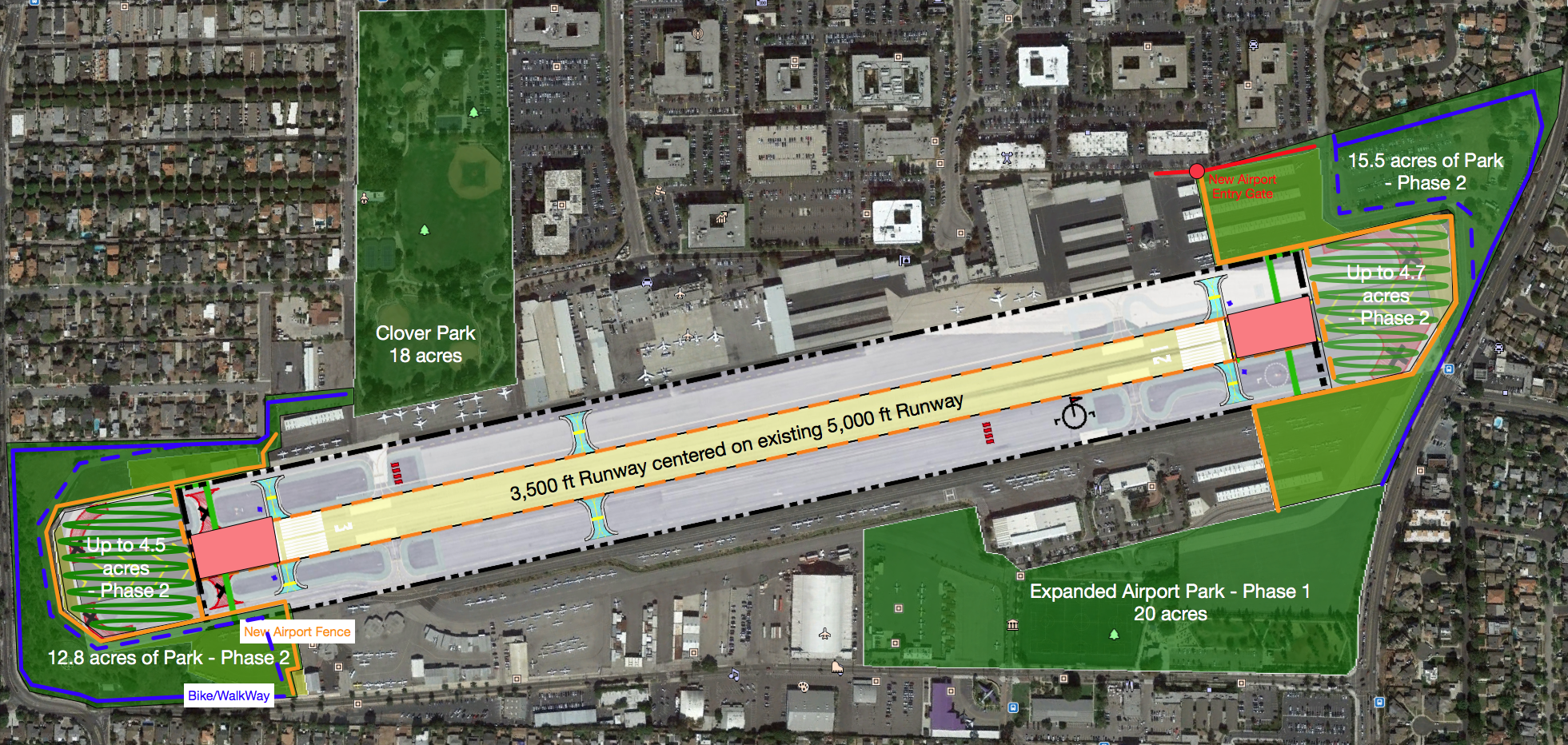
Figure 3 – Additional Park area added during Phase-2
Phase-2 park expansion
Figure 3 above shows that there is the potential to immediately free up additional acres of parkland for phase-2 of the ‘great park’ expansion following runway shortening. In fact, there is somewhere between 28 and 37 acres of land that can be used for this purpose (depending on where the border fence is placed). In that sense we are in much the same position as at the beginning of 2015, that is we have another huge chunk of potential parkland readily available, for which planning can begin almost immediately. Once again Council has an opportunity to re-affirm its unwavering commitment to Measure LC and the great park by fast-tracking this new park space, just as actually happened for the first 12 acres. At the same time the land freed up gives us the potential to resolve a significant issue caused by the current airport configuration:
- The two new parcels of land (one at the Western end, one at the Eastern end) that are to the sides of the raised/flat airport surface, and below it at the ends, give us the potential to connect the newly emerging Airport Park expansion to the rest of Santa Monica via easy bike and pedestrian access. This is particularly critical if the playing fields that are part of the expansion are to be used by SAMO High students since they would otherwise be forced to navigate either Bundy or 23rd, both of which are extremely dangerous (particularly the intersection at 23rd). By running two new bike/pedestrian routes (as shown in blue on Figure-3) round either end of the airport, we can resolve this issue while also giving better access to arts and other facilities and to SMC students moving between the main campus and satellites at the airport. The phase-2 contiguous border with the Airport Park expansion needs to be communicated with Mark Rios so that its presence can be incorporated into the Phase-1 park expansion currently in final design phase. Note that if the airport border fence (shown in orange) can be placed immediately beyond the end of the 300′ RSAs at either end as shown in the dashed orange lines (as opposed to just inside Douglas Loop as assumed in the solid green areas), over 9 acres of additional usable parkland (shown with squiggly lines) is available, and the existing Douglas Loop road around the airport can become bike/pedestrian paths instead (dashed blue lines).
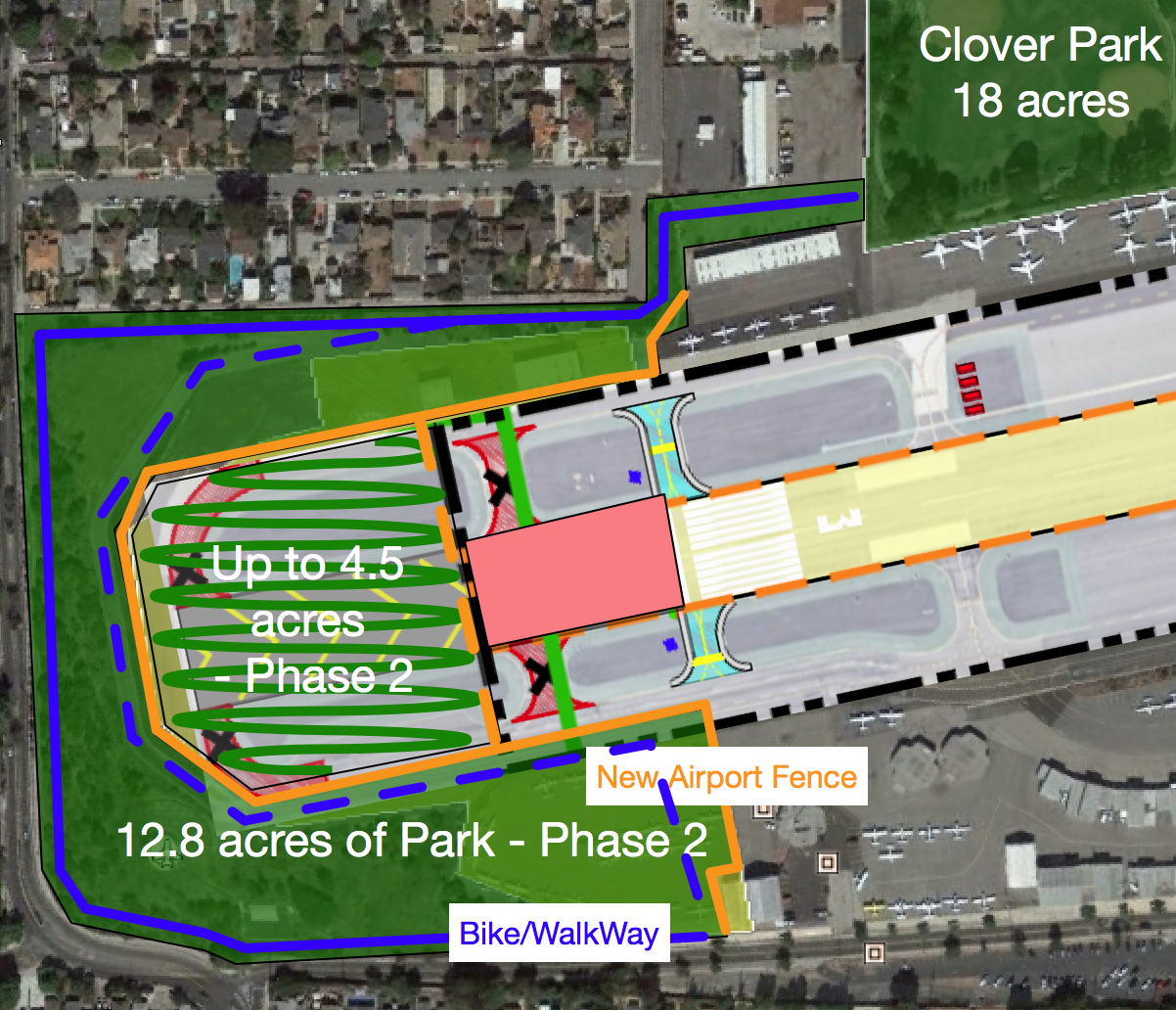
Fig-4 – Detailed view of 17 acres Western End Phase-2 Park Space (Click to Enlarge)
Figure 4 above shows a detailed view of the envisaged additional park space at the Western end, and of a suggested configuration of the revised airport footprint. The first point to realize is that the existing airport peripheral road, Douglas Loop (seen just inside the suggested inner park orange boundary) is at the top of a slope that falls from the airport surface down to the level of 23rd street. This slope is already in its natural state consisting of scrub, trees and vegetation along the hillside. The most conservative approach would be to move the existing airport perimeter fence (the orange line) to just inside Douglas Loop, making the road the uppermost limit of the park. This avoids the need to construct a new road through the park (just repurpose the existing road as a new park road), and allows people the potential to climb to this level and see the amazing views it affords (while still being outside the aviation perimeter). Leaving this roadway in place at the top of the hill is likely also necessary to avoid soil erosion issues. A new bike/pedestrian trail (the blue line) could be constructed down-slope and thus out of sight/danger from aircraft taking off from the reduced runway. This new trail would run along Airport Avenue on the south, up the side of 23rd (which would now have an unobstructed view of the new park and trails), and along the northern edge coming out near the fire station (or if possible connecting directly to Clover park behind the row of small hangars shown in the upper right of the image). By so doing this path affords direct pedestrian and bike access to Airport Avenue from the rest of Santa Monica. The existing contract to remove gunnite along Airport Avenue needs to be modified to take account of the planned existence of bike/pedestrian trail along the Western end of the road. It is also possible to route a bike path along Douglas loop (the dashed blue line) and so separate pedestrian and bike trails. If the airport boundary fence can be moved to immediately beyond the RSA (dashed orange line), and addition 4.5 acres of park space becomes available (shown with squiggly lines) although since this land would be directly below and in line with the flight path, it is unclear at this time what productive use could safely be made of this area, so it might simply be left open.
Note that at South-east limit of this park area there is a paved area of aircraft tie-downs which should be removed and the aircraft re-located. Other than that, and the construction of the new pedestrian/bike path, there is little if any major work to be done over and above tarmac removal for this park to come into use as 13 to 18 acres of completely un-structured natural habitat parkland marking the Western gateway into the City of Santa Monica and connecting directly to the existing 18 acres of Clover Park.

Fig-5 – Detailed view of 20 Acres Eastern End Phase-2 Park Space (Click to Enlarge)
Figure 5 above shows a detailed view of the envisaged additional park space at the Eastern end per the selected configuration of the revised airport footprint. Just as for the changes at the Western end, the existing airport peripheral road – Douglas Loop (seen just inside the suggested inner park boundary – orange line) is at the top of a slope that falls from the airport surface down to the level of Bundy. This slope is already in its natural state consisting of scrub, trees and vegetation along the hillside. The most conservative approach would be to move the airport perimeter fence (the orange line) to just inside Douglas Loop, making the road the uppermost limit of the park. This avoids the need to construct a new road through the park (just repurpose the existing road as a new park road), and allows people the potential to climb to this level and see the amazing views it affords (while still being outside the aviation perimeter). Leaving this roadway in place at the top of the hill is likely also necessary to avoid soil erosion issues. A new bike/pedestrian trail (the blue line) could be constructed down-slope and thus out of sight/danger from aircraft taking off from the reduced runway. The slope at this end is somewhat narrower in places so some widening might be required. This new trail would run along Bundy (which would now have an unobstructed view of the new park and trails), and along the northern edge of the existing open space (through the existing shady tree lined ‘avenue’ along the northern edge of the existing airport boundary, ending at the current airport gate at what is currently the end of Centinela. By so doing this path affords direct pedestrian and bike access to the expanded airport park from the rest of Santa Monica. As for the Western end, it is also possible to route a bike path along Douglas loop (the dashed blue line) and so separate pedestrian and bike trails. If the airport boundary fence can be moved to immediately beyond the RSA (dashed orange line), an addition 4.7 acres of park space becomes available (shown with squiggly lines) although since this land would be directly below and in line with the flight path, it is unclear at this time what productive use could safely be made of this area, so it might simply be left open.
The existing natural land to the north surrounds a parking lot which could be removed. To the Western end at the top (to the west of the line of Centinela within the airport boundary), an area of small hangars is freed up from aviation use and could thus be cleared for further park space, or alternatively converted to a parking lot for both park and aviation use (thus this tarmac would not be removed). Along the very top of this area is a road (currently within the airport boundary- shown in red) which would remain, and on it, at the point where the new airport perimeter fence (orange line) meets the road, a new security gate would be installed for entrance to the remaining aviation area.
On the southern side of the runway, a large additional area of aircraft tie-downs and some small hangars is released from aviation use. This area is contiguous with the existing Airport Park expansion and so should meld naturally with it. It is presumably too close to the end of the runway to put playing fields, so perhaps it too should be left as natural habitat for now (minimal cost) with just a few trails added to allow people to enjoy it and the incredible views it affords. In effect at the Western end of the runway, combining north and south parks and the strip of connecting land, we would have created a single contiguous park of nearly 40 acres with a mix of natural habitat to the north and planned uses to the south. Views of this park would delineate the Eastern gateway for people coming into Santa Monica.
The discussions above represent Airport2Park’s initial ideas for the disposition of this land once the surface has been removed, of course as for the Phase-1 expansion all this would go through a City visioning and then design process, so the ideas presented above should be taken simply as illustrative of the huge potential of this land.
If you look at all the Phase-2 parkland illustrated in Figure 3 above, we are talking about over 75 acres surrounding the airport, this alone represents some 2/3 of all Santa Monica’s current park space. When Phase-2 is complete, we will have increased Santa Monica’s park space by nearly 50 acres. That still leaves the City at almost 2 acres/1,000 residents (from its current 1.4 acres/1,000 – see 2017 LA Parks study), but still under recommended park levels of 3.5 acres/1,000 residents, and far short of LA with 9.5 acres/1,000 residents. When 2028 rolls around and the airport closes completely, we will already have Phase-3 planned, funded, and ready to start construction. When complete the ‘Great Park’ (Phase-3) will dwarf the gains thus far and make Santa Monica the park capital of the West Side.

Thanks for this posting…. The west end of the airport will make for an excellent stair climb and nature trail, with native plant restoration, and hopefully, hydration drinking water stations…. Looking backwards in time… Wish the **full** Western Parcel had been to park use, instead of the secret deal, but best to deal with things as they are… If for some reason the Aviation Forces win on the intent of the Brown Act Violation, then we should gird up for that battle, and vanquish the now moot point of the FAA kangaroo court grant extension… More on that later…
We are now at a turning point where the sneakers will hit the park or run into a chain link fence with a No Treaspassing sign. It is imparatve that the city council swiftly moves forward to remove the excess asphalt and cement beyond the 3500′ runway. If the true intent of the consent decree is to shutter the airport, rather than insure its operation for at least 12 years then following through on recovering the surrounding land should naturally happen with little delay. It should already be in process and a part of the plan. The FAA and the courts have clearly given their ok. The land is ours. If asphalt and concrete stays we have only the city to hold responsible.